Forecast improves for Friday, but severe weather still possible in Chambers County
Published 2:25 pm Thursday, January 11, 2024
|
Getting your Trinity Audio player ready...
|
While Chambers County is still forecasted to have extreme weather and wind, the likelihood of tornados has decreased, according to the National Weather Services (NWS) in Birmingham.
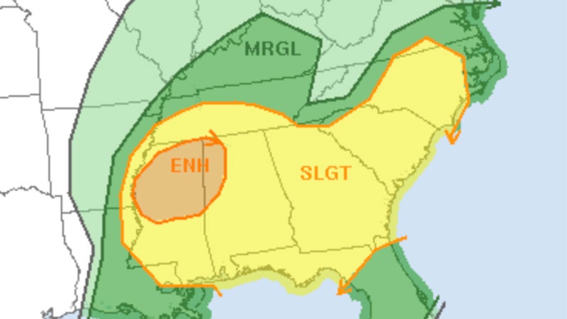
The risk has been downgraded from enhanced to slight, which will be at its height from 1 p.m. to 4 p.m. CT.
On Wednesday, a large portion of central Alabama was under an enhanced risk for severe weather. Now, according to the NWS’ Storm Prediction Center, Chambers County and most of Alabama have been downgraded to a slight risk, which is 2 of 5 on the severe weather scale.
While the county has been downgraded, Chambers is still likely to see severe storms and high winds. The enhanced risk for severe weather has been limited to the northwest portion of Alabama.
“You’ll see that the threat of tornadoes has dropped significantly. It’s really the threat of strong winds that is the concern for tomorrow now,” said John DeBlock, Warning Coordination Meteorologist at NWS Birmingham. “We can’t rule out a tornado, but the most significant threat tomorrow is severe winds.”
DeBlock added that the line of the storm is still the same moving along east of the I-65 corridor and south of the I-20 corridor.
“It’s going to be windy even ahead of the storms but when the storms come in, we’ll get some showers and thunderstorms. We could expect to see some additional wind gusts exceeding 50 miles per hour,” DeBlock said.
According to the NWS Birmingham website, residents should look for sustained winds between 15 to 30mph throughout the day, particularly during the afternoon.
He suggests people have ways of getting notifications and warnings during severe weather. In terms of preparations for strong winds, DeBlock said it is similar to tornado preparedness.
You want to secure any loose outdoor furniture…The ground is wet and one of our big concerns is that with strong gusty winds, we could have a lot of trees coming down,” DeBlock said. “As that line approaches, it wouldn’t hurt to get near your safe place in your house. Stay away from windows, give them the lowest level of your home.
Friday is the year anniversary of a tornado that tore through Chambers County. DeBlock gave insight into tornado frequency in the area.
“We have more deadly tornadoes than what most people consider traditional tornado alley out in the Midwest….We have a very vulnerable population. A lot of vulnerable folks throughout Mississippi, Alabama, Tennessee, and the combination of vulnerable people and severe weather is not good,” DeBlock said.
Along with the increased frequency of overnight tornados in the area relative to the Midwest, Deblock also points out the high number of people living in rural areas and in manufactured homes.
On Wednesday, a large portion of central Alabama was under an enhanced risk for severe weather. Now, according to the NWS’ Storm Prediction Center, Chambers County and most of Alabama have been downgraded to a slight risk, which is 2 of 5 on the severe weather scale.
“Severe thunderstorms capable of producing strong gusts, some potentially to 75 mph, and a few tornadoes, are possible across parts of the Southeast and into the Carolinas Friday through Friday evening,” the Storm Prediction Center said Thursday afternoon. “Highest chance of severe wind gusts is over northern and central Mississippi and far northwest Alabama Friday morning.”

